|
|||||||||||||||||
|
|||||||||||||||||
Argument For Rural Reserves on the
|
|||||||||||||||||


 |
 |
|
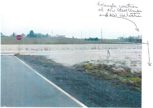
| Flooding at intersection of NW West Union Road and NW Helvetia Road, near West Union Elementary School. It happens every year. February 1996 |
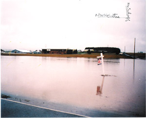
NW Helvetia Road looking east. NW Schaaf Road is on the right. Part of NW Helvetia Road is flooded. Properties located on east side of NW Helvetia Road are flooded and underwater. February 1996 |
|
 |
 |
|
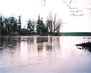
| Standing on NW Helvetia Road, looking west onto Standring's property. Flooding is over 200 feet wide at one place. February 1996 |
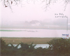
Flooding east and west of NW Helvetia Road near NW Pubols Road. Fields on both sides of NW Helvetia Road are flooded and underwater. February 1996 |
|
Oak Woodland Habitat
The southernmost Standring parcel contains at least 223 Oregon White Oak trees averaging 250 years old. Oak woodlands provide habitat for four at-risk species (one of which, the Acorn Woodpecker, is listed as a Species of Concern by the U.S. Fish and Wildlife Service). The Oregon Conservation Strategy published by the ODFW emphasizes proactively conserving declining species and habitats to reduce the possibility of future federal or state listings. Oak woodlands need to be in a rural environment to remain viable. This oak woodland is important plant and wildlife habitat.
Native American Cultural Site
Waibel Creek and the Oregon White Oak woodland on the southernmost Standring parcel formed an important site of the Atfalati people. The oak woodland and creek provided shelter, food and water during their summer and fall travels over the Tualatin Mountains. Numerous artifacts have been found in the woodland. Within a mile, the Atfalati had a historic gathering place at the Five Oaks, known as Chatakuin (place of big trees), the oak woodland, which provided acorns for food and trees for shelter, a sacred burial ground, and Waible Creek for water. This is a unique historic and cultural area.
Urban and Rural Reserve Factors
This area does not appear to meet urban reserve factor (8): Can be designed to avoid or minimize adverse effects of farm and forest practices...on nearby land. There does not appear to be a way to minimize the spillover urban traffic using the rural roads to avoid traffic on Hwy 26. This area is Foundation agriculture land adjacent to the UGB and is clearly suitable for a Rural Reserve. The area meets Rural Reserve factors for Natural Landscape Features (3)(a), (c) and (e). The floodplains in the area also meet factor (b).
Additional information
Urban designation not required for interchange
The reason given by the Core 4 for designating this area as urban is that it would facilitate the proposed and partially funded improvements to the Helvetia/Highway 26 interchange.
This reason for urban reserves for this area is unsupportable. According to Dick Benner, Senior Attorney in the Office of the Metro Attorney, it is not necessary to designate an area as urban reserve to support an interchange. As a practical matter, there are plenty of freeway interchanges in rural areas one need only look at Jackson School Road or all the US26 interchanges between Banks and the coast for examples.
Proposed land amount is too large
Regardless of whether area 8B is designated urban or rural reserve, the amount of land set aside is far larger than would likely be necessary to support the proposed interchange improvement, especially if the improvements are designed primarily to serve the urban uses south of US-26, and the industrial area to the northeast, which is the stated reason for the improvements.
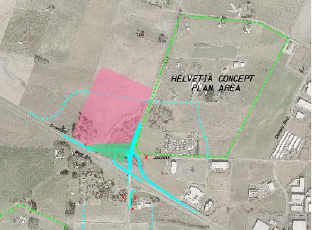
Save Helvetia spoke with Rian Windsheimer and Jeff Flowers of ODOT at the open house on December 9th. They indicated that the off-ramp that would expand capacity for westbound traffic heading south would likely only need to pass on the other side of the wetlands, and would probably occupy about the same amount of land on the northwest corner. This corresponds to the green area on the map below. This is a far smaller area than the 60-75 acres currently designated as area 8B. The boundaries of 8B should be redrawn to reflect the amount of land actually needed.
 |
|
The red shaded area approximately corresponds to proposed area 8B. The land likely needed for the interchange (green shading) is far less. Map adapted from ODOT JTA (Jobs in Transportation Act) project description. |
Urbanization on the fringe is expensive
Urbanizing these areas would increase dependence on the automobile for transit. It would move population areas away from the city core, lowering the overall density and making mass transit less feasible (and more expensive) for the rest of the city.
Metro studies indicate that urbanizing new areas is 2-3 times more expensive than redeveloping existing urban areas.
If the area is designated urban, the market will demand a higher price for the interchange land, thus raising the cost to taxpayers. Its best to designate it rural and save money!
Home • About us • Recent news • What you can do • Donate
Web site design and programming by Brian Beinlich • Contact the webmaster